The Maplewood Trail
The Maplewood Trail is a three mile section of the Genesee Riverway Trail located in the Maplewood section of Rochester, NY. Holy Sepulchre Cemetery is at the northern end of this section and Lowerfalls Park at the southern. The majority of this trail is in Maplewood Park which is maintained by the City of Rochester.
Over 100 years ago, Frederick Law Olmsted, the designer of Central Park in New York City, designed a park system for Rochester. He suggested two parks both located on the Genesee river, South Park, now Genesee Valley Park, had broad meadows and North Park, now Seneca and Maplewood Parks, featured the nearly 200 foot deep gorge of the Genesee River. Rochester's first park. Highland Park, an arboretum built on land donated by the horticulturists Ellwanger and Barry was also included in the Olmsted design.
Trail Description
Holy Sepulchre Cemetery - This cemetery was an early project of Bernard J. McQuaid,  the first bishop of Rochester. Installed as bishop on July 16, 1868 he decided that having five smaller cemeteries was impractical and planned for one large Catholic burial ground. In early 1871 he purchased 110 acres of land spanning Charlotte Boulevard (now Lake Avenue). One east side section was consecrated on Septrmber 10, 1871 and the first burial took place eight days later.
The buildings seen from the east entrance are All Souls' Chapel (1876) 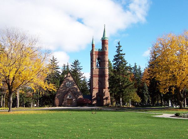 and the Bishops' Tower(1886). The cornerstone for the chapel was laid on April 23, 1876. The interior of the chapel was unfinished until the tower was added. The tower was to contain a water tank and a bell for tolling but was never used for these purposes. In 1938 a bishops' crypt was added to the base of the tower and it became known as the Bishops' Tower. The bell you can see in the photographs was moved from a chapel in Sonyea in 1998. It had been dedicated to Bishop McQuaid in 1901. Some notables in the cemetery are Colonel Patrick O'Rorke (the new bridge in Charlotte is named for him), "Rattlesnake Pete" Gruber and Patrick Barry (horticulturist).


St.Bernard's Seminary -  During an ad limina visit to Rome in 1878 the pope and other church officials had stressed to Bishop McQuaid the desirability of a diocesan seminary.
This would be a major undertaking but a building fund and a fund to support a faculty were established. In 1887 about 20 acres of land immediately south of Holy Sepulchre Cemetery were purchased. Spurred by a gift from Patrick Barry, building construction began in 1891 and the buildings were dedicated in August 1893. The seminary closed in 1982. Detailed information is available in St. Bernard's Seminary 1893 - 1968, Robert Francis McNamara, The Sheaf, Fifteenth Issue, St. Bernard's Seminary, Rochester, NY 1968. A copy is available in the Local History section of the public library.
During an ad limina visit to Rome in 1878 the pope and other church officials had stressed to Bishop McQuaid the desirability of a diocesan seminary.
This would be a major undertaking but a building fund and a fund to support a faculty were established. In 1887 about 20 acres of land immediately south of Holy Sepulchre Cemetery were purchased. Spurred by a gift from Patrick Barry, building construction began in 1891 and the buildings were dedicated in August 1893. The seminary closed in 1982. Detailed information is available in St. Bernard's Seminary 1893 - 1968, Robert Francis McNamara, The Sheaf, Fifteenth Issue, St. Bernard's Seminary, Rochester, NY 1968. A copy is available in the Local History section of the public library.
It should be noted that the red stone used in the buildings was obtained from a quarry on a farm in the vicinity of the Veteran's Memorial Bridge.
King's Landing - Proceeding south an elevated walkway connects buildings of the Kodak Research Labs followed by the King's Landing area. King's Landing was the first settlement in what is now the city of Rochester. It was realized very early that the water power in the area was ideal for running mills and that the products of the mills would be shipped via the Genesee River, Lake Ontario and the St. Lawrence River to Montreal and points beyond.
In the winter of 1796-97 several families led by Gideon King bought and settled land near what was to become Rochester's first port. The landing on the river was considered too valuable to be owned by one person so it was held in common by all settlers in the area. The King group established their settlement on the high bank immediately above the landing.and the area became known as King's Landing. It was here that the first American schooner on the Great Lakes was built in 1797. These settlers represent the early history of the area but the settlement was nearly wiped out by the "genesee fever" and abandoned in 1803. The area was resettled in 1809 by the seven Hanford brothers from Rome, NY and the area became known as Hanford's Landing. A good source for this history is King's Landing, Helen Edson Slocum, Rochester Historical Society, 1948.

Just past the Kodak buildings is the King's Landing Cemetery, Rochester's oldest. Turning left past the cemetery is a small parking area with a good view of the Genesee River. Looking SW are the buildings of Kodak Park which opened in 1891.
Eastman Memorial - In front of the earliest Kodak buildings is a small park containing a memorial to George Eastman.The memorial was dedicated on September 15, 1934.
"The monument at the center of the memorial... ...is a pillar of grayish-pink Georga marble, marked with striations of darker grey. It is simply carved with two bas-relief figures. On one face a woman raises the flame of aspiration. On the opposite side, a crouching male figure represents the science on which Mr. Eastman's work in photography was based. The central monument is set in a round sunken plaza paved with marble of a darker tint, brownish-pink. The marble disc on which the sculpted stone stands bears on one edge the inscription, "George Eastman, 1854-1932." Beneath the great central stone the ashes of Mr. Eastman rest in a bronze urn within a steel box."


Continuing south from the overlook, the Hanford Landing Road is crossed. 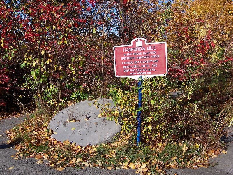 It now leads down to the Kodak Water Treatment Plant. Farther south two historical markers are found. One describes a palisaded Indian village and the second, Hanfords Mill. A millstone found in the area is at the base of the second marker. Behind the markers are a building and bridge, both parts of the Monroe County Pure Waters System. Steps here will take you to the bridge, which has a pedestrian walkway and offers a spectacular view of the river gorge. If the gate at the top of the steps is locked a more scenic approach is located about a quarter mile south. North of the bridge is the Kodak Treatment Plant occupying the former site of King's Landing. To the south is the Veteran's Memorial Bridge opened on December 27, 1931. Continuing across the bridge leads to Seneca Park and zoo.


Returning to the trail, across the road is Upper Maplewood Park. Just beyond the parking lot is a playground. At one time a yearly celebration of Iroquois/Seneca culture was held in the park. Proceed under the Veteran's Memorial Bridge. The areas on both sides of the river just south of the bridge were important in early Rochester. On the east bank was the town of Carthage and on the west Kelsey's Landing. Both will be discussed later. Continuing with occasional river views on your left you pass tennis courts. In 1906 that area contained a six hole golf course.
Passing Emmanuel Temple Church some dramatic vistas come into view. The island in the river is named Seth Green Island. The "father of American fish culture" was raised in Carthage and many of his early experiments were conducted from a tent camp he established on this island. He founded the trout hatchery in Caledonia, NY in 1864. It is the oldest in the US and raises brown trout.
Upper Maplewood Park - The initial open area you enter was known as the Maple Grove. It contained a beer garden and picnic area and was owned by Ellwanger, Barry. et al. They also established a resort, the Glen House(1870), on the river directly below the Maple Grove and in1878 added a hydraulic elevator for easier access. From 1870 to 1890 this was a major recreation area for Rochester. People would hike, view the falls, dine, dance, attend concerts, rent boats, fish and take excursion boats to Lake Ontario. The Glen House burned in in 1894 and in 1904 both properties became part of the Rochester park system. This park was designed by the firm of Olmsted Brothers and one of their 1904 plans shows a rose garden in the same area as the present garden. The 1909 Report of the Parks Commission states "nine varieties of the hardiest and the best roses have been planted in large masses. Each variety of roses is separated from the others by a number of white roses so that their colors will not be inharmonious."


To the left of the dove cote are two historic markers.
Kelsey's Landing -  In 1844 a road, Buell Avenue, was constructed north from the west side of the present Driving Park bridge to river level and Alexander Kelsey established a landing there. A warehouse and grain elevator were built and a regularly scheduled horse-drawn omnibus service was established to downtown Rochester. In the 1840's you could
take a nonstop boat to Detroit from Kelsey's Landing. It was also a departure point for
slaves escaping to Canada on the Underground Railway. For a few years it was Rochester's main port but shipping on the Genesee shifted to Charlotte when a railroad was built to it in the 1850's. Buell Avenue was built along the steep and unstable walls of the gorge and only the initial portion remains today.
In 1844 a road, Buell Avenue, was constructed north from the west side of the present Driving Park bridge to river level and Alexander Kelsey established a landing there. A warehouse and grain elevator were built and a regularly scheduled horse-drawn omnibus service was established to downtown Rochester. In the 1840's you could
take a nonstop boat to Detroit from Kelsey's Landing. It was also a departure point for
slaves escaping to Canada on the Underground Railway. For a few years it was Rochester's main port but shipping on the Genesee shifted to Charlotte when a railroad was built to it in the 1850's. Buell Avenue was built along the steep and unstable walls of the gorge and only the initial portion remains today.
Casconchiagon - 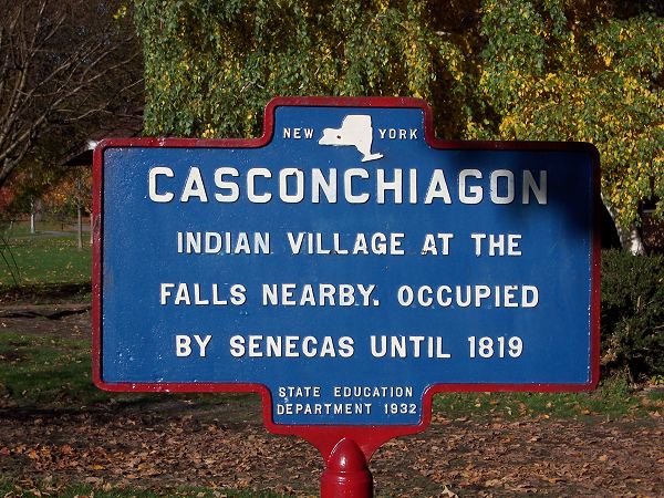 This is a Seneca word meaning "river of many falls". The most recent village was located on Lorimer Hill which is the hill west of the park. During the middle 1800's many artifacts were found in this area.
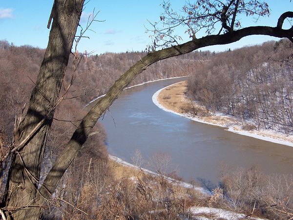
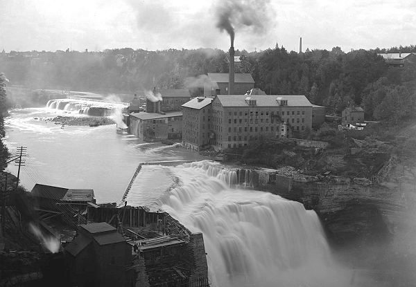
Proceeding south across Driving Park Avenue a long downhill leads to Lower Falls Park. About half way down the hill a paved trail on the left leads to a falls overlook. Returning to the downhill a left at the bottom leads to the next overlook. This 86 foot high falls is Rochester's highest. The buildings on the east side of the falls are RG&E's Station #5, a hydro plant. The operation of the plant is described on a sign at the Middle Falls overlook. The east side service road was built in the middle 1950's. East of the bridge is the Kodak Hawkeye plant and beyond it to the north is the Rochester School for the Deaf (1876).The bridge is the fourth on this site. The first, built in 1819, was the largest single arch wooden bridge ever built. It had a twelve month warrantee and fell after fifteen months. The second was a suspension bridge opened in April 1856. It fell in an ice storm in July 1857. A steel arch bridge, opened in 1890, lasted for over 100 years before being replaced by the current bridge.
Initially the Genesee River flowed through the Irondequoit Valley entering Lake Ontario via Irondequoit Bay. This route was blocked at the end of the last Ice Age and the present course established. In the gorge walls you are looking at 20 million years of sedimentation in a gorge cut in the last 10 thousand years. The sedimentation took place during the late Silurian Period about 400 million years ago.
The area you are now in was known as McCrackenville after three brothers from Batavia, NY who moved to Rochester after the War of 1812. There was a residential area along Lake Avenue and an industrial area on this site, using a mill race supplied with water from above the Middle Falls. The residential area was not successful but flour mills, paper making, carpet making, veneering and furniture making plants were located here for over 100 years. The last plant burned in 1964 and the area was eventually covered with material removed during construction projects in downtown Rochester. The plants were at water level so your next stop alongside the Lower Falls will give you an idea of how much material covers old McCrackenville.


 The last stop is the Middle Falls overlook. Be sure to read the information and to stop at the "seat of forgetting and remembering" as you return to Driving Park Avenue.


