Gorge East
Heading east across the Driving Park bridge a good view of the Lower Falls is on the south side. Proceed to St. Paul Street and turn left. The building on the corner is the Kodak Hawkeye works. In the late 1890's George Eastman bought the Blair Camera Company of Boston and moved it to the north side of this site. Blair had a line of cameras called Hawkeye's, a name which was used by Kodak. The Blair building was removed a few years ago.
A little further to the north  is the campus of the Rochester School for the Deaf (1876).
The building at 1545 St. Paul is one of the oldest in the area. Information on the school is
available at www.rsdeaf.org/pages/about-rsd/history.
is the campus of the Rochester School for the Deaf (1876).
The building at 1545 St. Paul is one of the oldest in the area. Information on the school is
available at www.rsdeaf.org/pages/about-rsd/history.
The next intersection, St. Paul and Norton, was the heart of the old town of Carthage. Rochester's development was greatly slowed by the War of 1812 but by 1814 growth had resumed. Mills were built using a race above the Upper Falls and products were taken to King's Landing for shipment. The idea was advanced that mills at the Lower Falls would be much closer to the river landings and shipping difficulties reduced. In 1816 a group led by Elisha Strong purchased a tract of land on the east side of the Genesee River in the vicinity of the Lower Falls and in 1817 the land was surveyed and a town laid out. The tract ran from the Genesee River to Clinton Avenue and from Clifford Avenue to Ridge Road. By 1818 the village was thriving. There were two industrial areas. The Mill Flats were between the Lower and Middle Falls and Carthage Landing was at the end of the Switchback Trail which can be accessed from Seth Green Drive. Material was moved between the Landing and the high bank via an inclined rail line.
Travelers on the Ridge Road would come to the river gorge and turn south and go to Rochesterville to cross the river on the bridge built there between 1810 - 1812. The promoters of Carthage realized that without a bridge travelers would bypass their town and continue to Rochesterville. Accordingly, the 1817 map showed a short street ending at the river gorge. It was called Bridge Street.  In May 1818 the construction of a bridge spanning the gorge in the vicinity of the present Driving Park bridge was begun. An average of 22 men took nine month to complete the bridge. At 700 feet long and 200 feet above the river it was the largest single span wooden arch bridge ever constructed. It was noted early on that the center of the span was built too thinly and work was done to correct the problem. The bridge opened in February 1819 and came with a one year warrantee. As you may have guessed the bridge fell after 15 months in May 1820.
To  compensate for the loss of this bridge it was decided to build a river level bridge across the Middle Falls. At this time there was frequent springtime flooding and this bridge was washed away in 1828, rebuilt and washed away again in 1835. This ended attempts to span the Genesee in this area.
The fatal blow to Carthage was the completion of the Erie Canal through Rochesterville in 1823. In 1831, to keep Carthage thriving, Rochester's first railroad was built connecting Carthage with the Erie Canal. In 1834 the village of Rochesterville became the city of Rochester and Carthage was incorporated into the city. The railroad was abandoned a few years later.
In the 1850's another attempt was made to put a high bridge across the river at the present day Driving Park Avenue. This time a suspension bridge was built.  The bridge was declared ready in July 1856 but users felt it was unstable and it was quickly closed. The wooden arch bridge was 30 feet wide and the suspension bridge only 19 feet wide. Cables anchored in the gorge were added to stabilize the bridge and it reopened in September. The bridge went into use but the city felt the work was inadequate and refused to accept the bridge. In April 1857 an ice storm greatly increased the weight of the bridge and one of the cast iron anchors snapped and the bridge fell into the gorge.
In 1890 a steel arch bridge was completed and lasted over 100 years before being replaced by the current bridge.
A left turn onto Seth Green Drive  quickly leads to a left turn which is the RG&E access road to the Lower Falls. Continuing straight on Seth Green Drive the top of the Switchback Trail to the river is on the west side after about a quarter mile.
This may be a good place to give some distances. From the intersection of Norton and Seth Green with St. Paul it is 0.75 miles to the entrance of Seneca Park. From the entrance it is 0.5 mile to the zoo and another 0.5 mile to the north end of Trout Lake.
North on St. Paul you cross over the Keller Sreet Expressway and reach the intersection with Ridge Road East. In 1835 Myron Holley bought 135 acres at this intersection and built his home Rose Ridge. Holley was a promoter of the Erie Canal and was Supervisor of its construction. He became involved in the abolitionist movement and eventually sold Rose Ridge to get funds to start an anti-slavery newspaper, the Rochester Freeman. He was also a founder of the Liberty Party, one of the first abolitionist and equal rights groups to run candidates for office.
One-quarter mile further turn left and enter Seneca Park.  This park, one of Rochester's original parks was designed by Frederick Law Olmsted, the designer of New York's Central Park. A structure on the left is part of Rochester's Pure Water System and an overlook on the west side gives a good view of the walkway across the Genesee River and of the site of Rochester's first settlement, King's Landing.
Continuing the Seneca Park Zoo will be on your right.  Information on the zoo is available at www.senecaparkzoo.org. Clicking on zoo happenings and about the zoo will bring you to information on the history of the zoo.
At this point you will encounter a gate in the road. From here you can reach Trout Lake by two routes. You can continue straight on the road or go left along the fence to a trail that runs along the edge of the gorge. The trail is the more scenic route.
Information on the zoo is available at www.senecaparkzoo.org. Clicking on zoo happenings and about the zoo will bring you to information on the history of the zoo.
At this point you will encounter a gate in the road. From here you can reach Trout Lake by two routes. You can continue straight on the road or go left along the fence to a trail that runs along the edge of the gorge. The trail is the more scenic route.
Seneca Park was designed by Fredrick Law Olmsted, the designer of Central Park in New York City. It was originally called North Park and the original plan extended from the present Driving Park bridge to north of Trout Pond and boat docks along the river were included. Land was to be acquired as it became available but the initial vision was never fully implemented.
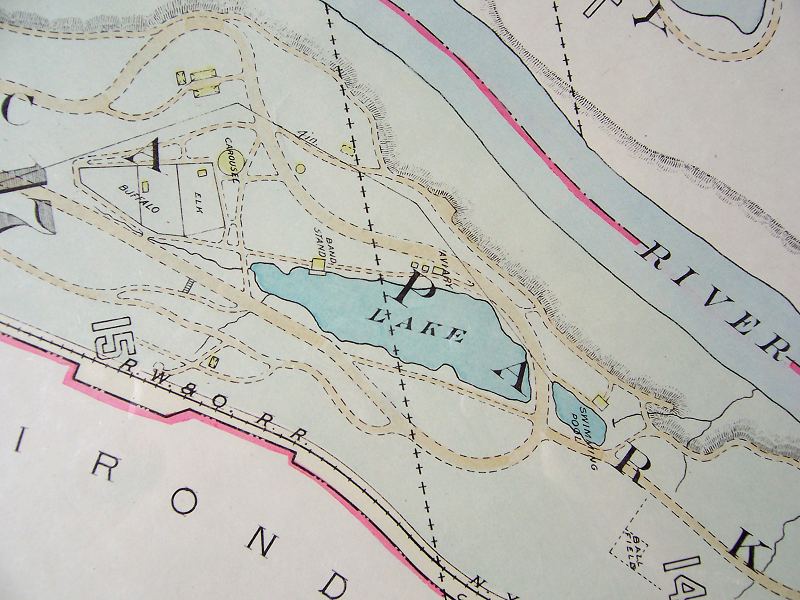

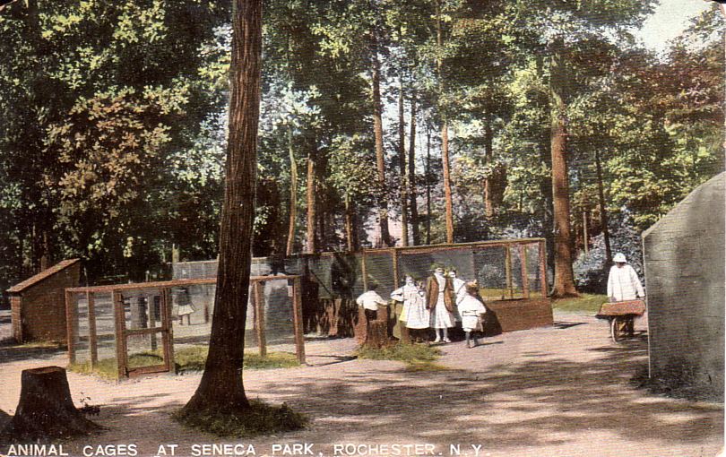
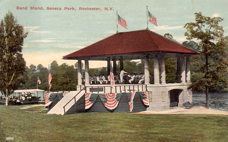
The maps from 1926 and 1936 show the changing nature of the park. The aviary, swimming pool and buffalo and elk areas present in the earlier map have been removed by the time that second map was made. You can also see a carousel not in the initial plans has been built. Currently the animal cages have been replaced by a zoo and the band stand, swan boats and carousel no longer exist.


From the end of Trout Lake it is about 0.4 miles to a set of steps leading to a dock in the Genesee River. You are now entering the area of the Irondequoit Flats and the Rifle Range. At one time a dock in this area gave access to the 1877 Staudenmaier establishment. "They occupied a building on the high river bank, with a long platform attached and steps leading down the high banks to the river. The old steamboat "The City of Rochester" made stops there and the passengers ascended the stairs to have luncheon and refreshments. About seven years later this building was moved about three hundred yards to the east and several other buildings were erected that gave the impression of a trading post.." This place was famous for pit clam bakes which continued until 1948. Clam shells can still be found in the area.
To the east below the bank you see was the Rifle Range. Beginning in 1875,
"this shooting range, maintained by the state, was also used as a drilling ground, for larger practice and maneuvers by the State Cavalery, Artillery and Infantry and later by the First and Eighth Separate Companies as well as the Naval Reserve. This shooting range became known all over the state for one of the best and often large crowds came to view the maneuvers. These target practices and other maneuvers were held in Rifle range for more than 25 years." From Irondequoit Story, Maude I. West, Town Historian, 1957.
A fence at the north end of the park is reached and for a short distance the distance between the gorge and the park's east boundary decreases. Looking to the east you will notice that the high bank goes east and out of sight. You are in a large area known as the Irondequoit Flats. This area was eroded thousands of years ago by a meander of the Genesee River. Remember that the gorge was cut in the last 10,00 years so it was not that long ago that you were at river level. Further along the high bank on the east side returns. You will exit the park on the east side and continue north on the old rail bed. There are plans to convert the rail bed to a trail.
On the west side of the river are the docks of Turning Point Park. Opposite the turning basin, there is a point on the east side of the river called Rattlesnake Point. When the Rochester area was first settled there were many rattlesnakes with the largest concentration said to be at this point. You will know you are there when you see the reddish soil and a good overlook.

The distance from Rattlesnake Point to the O'Rorke bridge is about 1.1 miles. Construction is to begin soon on a trail from Pattonwood Drive to Irondequoit Bay.
Shedville - A little south of the O'Rorke Bridge, it is an area of boat docks and brightly colored sheds.


On the east side of the river between the bridge and the lake are several marinas, the Rochester Yacht Club and the U.S. Coast Guard Station.